SciGraphs
  • Home
  • Guide
  • Panel Reference
  • Tutorials
  • Notebooks
  • Examples
  • API
  1. SciGraphs
  • Guide
    • Introduction
    • Installation
    • System architecture
    • The sidebar interface
    • The end-to-end workflow
    • Writing pipeline files
  • Panel Reference
    • Panel Reference
    • SciGraphs tab
      • Data
      • Layout & Positioning
      • Graph Algorithms
      • Analysis
      • Visualization
      • Export & Tools
      • Reproducibility
    • OSMnx tab
      • OSMnx
      • Download
      • Graph Operations
      • Network Attributes
      • Routing & Paths
      • Accessibility
      • Statistics & Centrality
      • Features & POIs
      • Elevation & Terrain
      • IO / Export
    • City2Graph tab
      • City2Graph
      • Data Import
      • Urban Morphology
      • Transportation
      • Mobility (OD Matrix)
      • Graph Tools
      • Proximity Graphs
      • Metapath Analysis
      • GeoAI Export
  • Tutorials
    • Panel tutorials
    • SciGraphs panels
      • SciGraphs panels
      • SciGraphs · Import an abstract graph
      • SciGraphs · Lay out a graph
      • SciGraphs · Run graph algorithms
      • SciGraphs · Analyze a graph
      • SciGraphs · Make a figure
      • SciGraphs · Export a graph
      • SciGraphs · Freeze and replay a pipeline
    • OSMnx panels
      • OSMnx · Download a street network
      • OSMnx · Clean up the graph
      • OSMnx · Add edge attributes
      • OSMnx · Find routes
      • OSMnx · Measure accessibility
      • OSMnx · Compute statistics
      • OSMnx · Download features (POIs)
      • OSMnx · Save, export and cache
      • OSMnx · Elevation, DEM & 3D terrain (La Paz)
      • OSMnx · Basemaps & API textures (La Paz)
    • City2Graph panels
      • City2Graph · Import urban data
      • City2Graph · Build a morphological graph
      • City2Graph · Build proximity graphs
      • City2Graph · Analyze metapaths
      • City2Graph · Model public transport
      • City2Graph · Map an OD matrix
      • City2Graph · Post-process a graph
      • City2Graph · Export for GeoAI
  • Jupyter Notebooks
    • Jupyter notebooks
    • 00 · Environment check
    • SciGraphs
      • 01 · Abstract graphs
      • 02 · Layouts
      • 03 · Centrality and communities
      • 04 · Paths, trees and flows
      • 05 · Topology
    • OSMnx
      • 06 · Downloading a street network
      • 07 · Street geometry and orientation
      • 08 · Routing
      • 09 · Accessibility and places
      • 10 · Centrality and export
      • 11 · Terrain
      • 12 · Imagery
    • City2Graph
      • 13 · Urban morphology
      • 14 · Public transport (GTFS)
      • 15 · Mobility (origin-destination matrices)
      • 16 · Proximity graphs
      • 17 · Metapaths and the 15-minute city
      • 18 · Functional clustering, end to end
    • Reproducibility
      • 19 · Reproducible pipelines
      • 20 · A local model writes the specification
  • Examples
    • Examples
    • Tutorial 1: A combinatorial graph from a file
    • Tutorial 2: A geospatial flow map on a globe
    • Tutorial 3: An urban network on terrain
    • Tutorial 4: A sparse matrix from SuiteSparse
    • Tutorial 5: A reproducible pipeline
  • API
    • Python API
    • sg.graphs
    • sg.preview
    • sg.render
    • sg.context
    • sg.thin
  • Reference
    • Pipeline options reference

SciGraphs

Graph visualization and analysis within Blender

GitHub Read the guide Tutorials

SciGraphs is an open-source Blender extension for graph ingestion, analysis, and 3D rendering. Networks become native Blender objects driven by Geometry Nodes, and analytical results (centralities, communities, topological invariants) are stored as named attributes that drive color, scale, and animation. Analysis comes from NetworkX, igraph, and Graphviz; rendering from Cycles and EEVEE. Node positions come either from a layout algorithm or from the data’s own coordinates: geospatial, sparse-matrix, mesh, or the multi-layer urban graphs the City2Graph module builds.
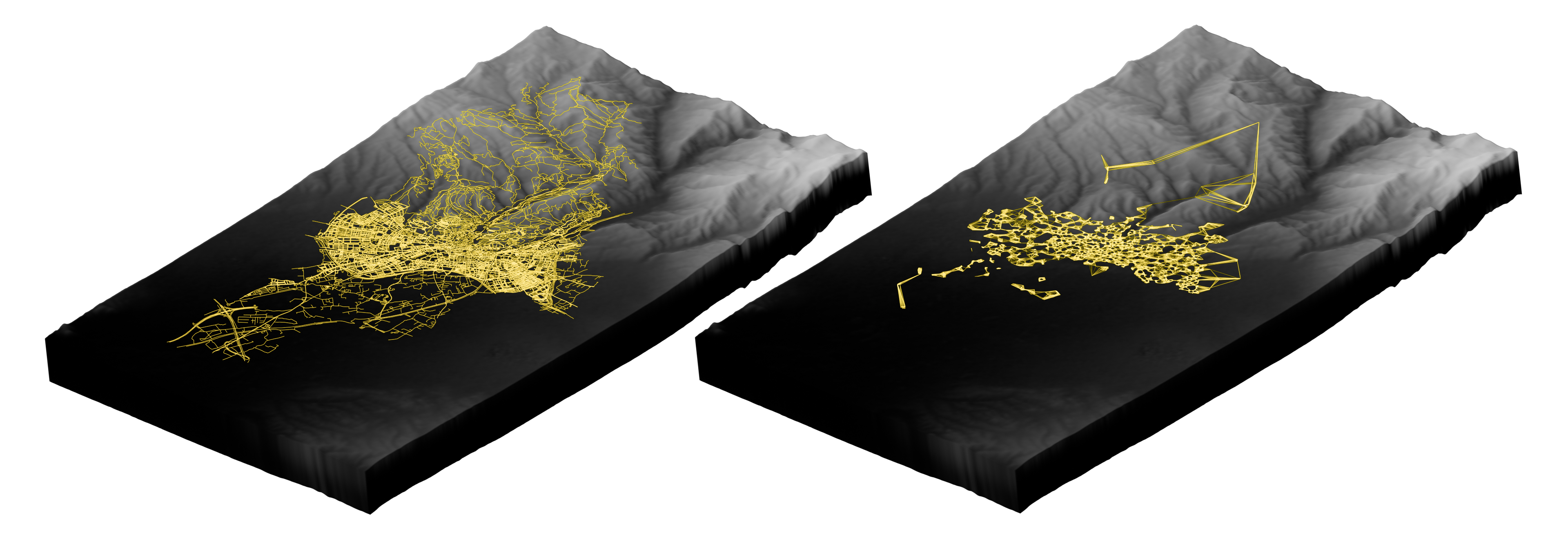
Granada, Spain: a 37,814-intersection street network plus a 20-NN amenity proximity graph draped onto SRTM 30 m terrain.

Where to start

Guide

Concepts, installation, and the end-to-end workflow.

Read the guide →

Panel reference

Every panel and subpanel in the sidebar.

Browse panels →

Tutorials

Walkthroughs of each panel, plus end-to-end examples.

Start a tutorial →

Citing SciGraphs

SciGraphs is described in Visualization and Analysis of Graphs with SciGraphs, José Marín, Ignacio Marín, Ignacio García-Fernández, The Eurographics Association, 2026.

@article{marin2026visualization,
  title={Visualization and Analysis of Graphs with SciGraphs},
  author={Mar{\'\i}n, Jos{\'e} and Mar{\'\i}n, Ignacio and Garc{\'\i}a-Fern{\'a}ndez, Ignacio},
  year={2026},
  publisher={The Eurographics Association}
}
Back to top

SciGraphs is released under the GPL-3.0-or-later license.

 
  • Edit this page
  • Report an issue
  • Maintainer: José Marín