import importlib
import json
import os
import pathlib
import sys
import tempfile
import time


def find_repo():
    """Locate the SciGraphs repository, without relying on the cwd.

    In a normal Jupyter the kernel starts per notebook with the cwd set to its
    folder. Not here: the kernel lives inside Blender and existed before you
    opened anything, so the cwd is wherever Blender was launched from. What the
    extension does know is which folder it is serving to JupyterLab.
    """
    candidates = []
    try:
        import bpy
        prefs = bpy.context.preferences.addons[
            "bl_ext.user_default.jupyter_blender"].preferences
        candidates.append(pathlib.Path(bpy.path.abspath(prefs.notebook_dir)))
    except Exception:
        pass
    candidates.append(pathlib.Path.cwd())

    for base in candidates:
        for directory in (base, *base.parents):
            if (directory / "SciGraphs" / "api" / "graphs.py").is_file():
                return directory

    raise RuntimeError(
        "Cannot find the SciGraphs repository. Point at it by hand:\n"
        "    sys.path.insert(0, '/path/to/SciGraphs-1/notebooks/tools')")


sys.path.insert(0, str(find_repo() / "notebooks" / "tools"))

import bpy
import networkx as nx
import numpy as np

# `nb` must import first: it puts this repository on sys.path, so the
# `SciGraphs` import below reads this tree, not the copy Blender installed.
import nb
from nb import check

from SciGraphs import api as sg10 · Centrality and export
Betweenness on a street network concentrates: the busiest 5 % of junctions carry 23 % of it, and of streets, 26 %. The notebook computes it on intersections and, through the line graph, on the streets themselves, which is the reading most urban analysis wants.
It also closes the suite by asking what survives leaving it. Of eight export routes tabulated, every GraphML, GEXF and JSON export comes out undirected regardless of the graph, one route loses 12 of 375 segments to a silent default, another turns every attribute into a string, and only the GeoPackage round trip returns float64 values unchanged.
The finding easiest to miss: Use Length Weight does nothing at all while Use Rustworkx (Fast) is ticked, because the fast path loads the lengths and then calls a function that takes no weight argument. The weighted answer, which moves three of the top five junctions, sits behind what reads as a performance switch.
10 · Centrality, and getting the answer back out
The last of the five-notebook OSMnx suite. Notebook 06 got a street network into Blender, 11 measured its edges, 12 routed over it, 13 asked what it reaches. This one asks which streets the network makes important, and how to get that answer out.
osmnx_centralityis notcalculate_centrality: different sources, different treatment of direction, different destinations. The OSMnx one offers the line graph, so betweenness is a property of streets rather than of intersections.- Whether it honors edge weights. The generic operators cannot:
GraphDatahas no weights field (core/algorithms/graph.py:3, notebook 03). The OSMnx one has its own code path and aUse Length Weightcheckbox, and section 2’s answer is not the one that checkbox implies. - What survives each of the eight export routes. Half carry the numbers, and none says which.
Study area: Ciutat Vella, València (39.4699, -0.3763), 600 m, drive, the same disc as notebook 06, so the Overpass response is already cached. Betweenness costs O(nm) shortest paths: 243 intersections is sized for the analysis, not for the picture.
0 · Setup
The cache goes first, as always
nb.osmnx() sets ox.settings.cache_folder and use_cache; notebook 06 covers why the second matters to a shared Overpass endpoint. It has to run before the first operator, because the importer imports the same osmnx module object this notebook does.
ox = nb.osmnx()
print(f"osmnx        {ox.__version__}")
print(f"cache_folder {nb.rel(ox.settings.cache_folder)}")
osmnx 2.0.7
cache_folder notebooks/data/cache/osmnxThe installed add-on, and why the modules come from there
The operators run inside the copy of SciGraphs that Blender registered, and the graph they leave behind lives in a module-level dict inside that copy. import SciGraphs reaches a different module object with an empty cache, and every get_osmnx_graph would come back None. So the four modules below are fetched from the installed package by name, as in 10 to 13.
CENTER = (39.4699, -0.3763)      # Ciutat Vella, València
RADIUS_M = 600

INSTALLED = next(k for k in bpy.context.preferences.addons.keys()
                 if k.rsplit(".", 1)[-1].lower() == "scigraphs")
graph_cache = importlib.import_module(INSTALLED + ".core.osmnx.graph_cache")
# `scigraphs_core` is a wheel: one copy in site-packages, shared by the notebook
# and the operators, so the installed/working-tree split does not apply to it.
mesh_bridge = importlib.import_module("scigraphs_core.osmnx.mesh_bridge")
sg_centrality = importlib.import_module("scigraphs_core.osmnx.centrality")
sg_mesh_utils = importlib.import_module("scigraphs_core.mesh.mesh_utils")

print("add-on package:", INSTALLED)
add-on package: bl_ext.user_default.scigraphsTwo helpers
download(...) writes every OSMnx scene property before firing scigraphs.import_osm_graph. The operator reads all of them off scene.scigraphs, so a property left set by an earlier cell is the easiest way to get a graph you did not ask for; this resets the lot.
node_attribute(...) puts a per-node quantity on the mesh so a figure can be colored by it. mesh_bridge.transfer_node_attribute_to_mesh does the first half (section 4 uses it) but leaves every street-shape vertex at 0.0, and an OSMnx import at retain_geometry=True is mostly street-shape vertices. Here each takes the mean of the two intersections its street runs between. That changes the attribute’s floor, not the picture: a POINT attribute colors the node spheres and the tubes stay neutral, as figure 1 shows.
def download(network_type='drive', simplify=True, distance=RADIUS_M):
    """Set every OSMnx scene property, then run `scigraphs.import_osm_graph`."""
    props = bpy.context.scene.scigraphs
    props.osmnx_download_method = 'POINT'
    props.osmnx_network_type = network_type
    props.osmnx_simplify = bool(simplify)
    props.osmnx_retain_all = False
    props.osmnx_truncate_by_edge = True
    props.osmnx_retain_geometry = True
    props.osmnx_custom_filter_preset = 'NONE'
    props.osmnx_custom_filter_text = ""
    props.osmnx_which_result = 0
    props.osmnx_scale = 0.001
    props.osmnx_place_name = ""
    props.osmnx_address = ""
    props.osmnx_latitude, props.osmnx_longitude = CENTER
    props.osmnx_distance = int(distance)

    started = time.time()
    try:
        result = bpy.ops.scigraphs.import_osm_graph()
    except RuntimeError as exc:          # the operator reports and cancels
        print(f"  import_osm_graph failed: {exc}")
        return None
    if 'FINISHED' not in result:
        return None
    obj = bpy.context.active_object
    obj["download_seconds"] = round(time.time() - started, 2)
    return obj


def node_attribute(obj, values, name):
    """Write a per-node quantity onto the mesh, filling the street geometry.

    `values` maps node id -> number. Returns (intersections written, array).
    """
    mesh = obj.data
    ids = str(obj.get("nodes_data", "")).split(",")
    array = np.zeros(len(mesh.vertices), dtype=np.float64)
    filled = np.zeros(len(mesh.vertices), dtype=bool)

    def key(text):
        return int(text) if text.lstrip("-").isdigit() else text

    for index, node_id in enumerate(ids):
        if index >= len(array):
            break
        value = values.get(key(node_id))
        if value is not None:
            array[index] = float(value)
            filled[index] = True

    edge_verts = np.empty(len(mesh.edges) * 2, dtype=np.int32)
    mesh.edges.foreach_get("vertices", edge_verts)
    edge_verts = edge_verts.reshape(-1, 2)
    for (u, v), indices in mesh_bridge.build_edge_mapping(obj).items():
        a, b = values.get(key(u)), values.get(key(v))
        if a is None or b is None:
            continue
        middle = 0.5 * (float(a) + float(b))
        for edge_index in indices:
            for vertex in edge_verts[edge_index]:
                if not filled[vertex]:
                    array[vertex] = middle

    if name in mesh.attributes:
        mesh.attributes.remove(mesh.attributes[name])
    layer = mesh.attributes.new(name=name, type='FLOAT', domain='POINT')
    layer.data.foreach_set("value", array.astype(np.float32).tolist())
    return int(filled.sum()), array


sg.graphs.clear_scene(keep_anchor=False)
props = bpy.context.scene.scigraphs
print("scene cleared")
scene clearedThe network
net = download('drive')
net.name = "Streets_drive"
G = graph_cache.get_osmnx_graph(net)

print(f"{G.number_of_nodes()} intersections, {G.number_of_edges()} directed "
      f"street segments, {type(G).__name__}")
print(f"mesh: {len(net.data.vertices)} vertices, {len(net.data.edges)} edges")
print(f"downloaded in {net['download_seconds']} s")

check("the network is in the scene and carries a graph",
      bool(net.get("is_osmnx")) and G.number_of_nodes() > 100)
Downloading OSM network (POINT)...
  Point: (39.46989822387695, -0.37630000710487366), radius: 600m
  Download completed in 0.27s
Total import time: 0.30s
  Nodes: 243, Edges: 375

Creating OSMnx graph: 243 nodes, 375 edges...
  Created 243 intersection vertices
  Created 361 street edges in 0.01s
Total OSMnx graph creation time: 0.01s
Graph saved to ~/.config/blender/5.2/scripts/addons/scigraphs_osmnx_cache/39.4699_-0.3763_drive.graphml
Graph cached to: ~/.config/blender/5.2/scripts/addons/scigraphs_osmnx_cache/39.4699_-0.3763_drive.graphml
Info: Downloading network from OpenStreetMap (POINT)...
Info: Graph cached as: 39.4699_-0.3763_drive.graphml
Info: Imported: 243 intersections, 375 street segments, 31.8 km total
243 intersections, 375 directed street segments, MultiDiGraph
mesh: 1374 vertices, 1492 edges
downloaded in 0.33 s
[PASS] the network is in the scene and carries a graphTrueChecking that this is the graph that was asked for
Two reasons from notebook 06, both able to hand you a different network without an error.
The GraphML cache filename does not identify the graph. It is built from the coordinates and network type alone (core/osmnx/cache.py:78-105, written at data_operators.py:659 and :661), so the radius, simplify, retain_all and any custom filter are absent from the key: six different downloads in notebook 06 all wrote to 39.4699_-0.3763_drive.graphml. A fallback read can return a 600 m graph where 300 m was asked for, and centrality on the wrong graph still looks like an answer.
The cleaning operators replace the cached graph and never rebuild the mesh: osmnx_simplify, osmnx_consolidate, osmnx_to_undirected, osmnx_to_digraph, osmnx_largest_component and all three truncations (graph_operators.py:477-480, 518-521, 575-578, 663-666, 707-710, 754-757). A centrality written onto the stale mesh lands on the wrong vertices, and anything exported afterwards exports the old graph. This notebook calls none of them.
The comparison is against OSMnx called directly with the float32 center the operator really used (notebook 06 §1: the number you type is not the number that goes over the wire).
queried = (props.osmnx_latitude, props.osmnx_longitude)
direct = ox.graph_from_point(queried, dist=RADIUS_M, network_type='drive',
                             simplify=True, truncate_by_edge=True)

print(f"asked for        {queried[0]!r}, {queried[1]!r}, {RADIUS_M} m, drive")
print(f"OSMnx directly   {direct.number_of_nodes()} nodes, "
      f"{direct.number_of_edges()} edges")
print(f"in the scene     {G.number_of_nodes()} nodes, {G.number_of_edges()} edges")
print(f"simplified flag  {G.graph.get('simplified')!r}")
print(f"mesh says        num_nodes={net['num_nodes']}, num_edges={net['num_edges']}")

check("the graph in the scene is the one that was requested",
      set(direct.nodes) == set(G.nodes)
      and direct.number_of_edges() == G.number_of_edges(),
      "not a stale cache entry from another radius")
check("it is simplified, as asked", bool(G.graph.get("simplified")))
check("the mesh and the graph agree on how big the network is",
      int(net["num_nodes"]) == G.number_of_nodes()
      and int(net["num_edges"]) == G.number_of_edges(),
      "no cleaning operator has run between the import and here")
asked for 39.46989822387695, -0.37630000710487366, 600 m, drive
OSMnx directly 243 nodes, 375 edges
in the scene 243 nodes, 375 edges
simplified flag True
mesh says num_nodes=243, num_edges=375
[PASS] the graph in the scene is the one that was requested — not a stale cache entry from another radius
[PASS] it is simplified, as asked
[PASS] the mesh and the graph agree on how big the network is — no cleaning operator has run between the import and hereTrueAnd that length is in meters
Sections 2 to 5 all weight by length. osmnx_add_edge_lengths computes great-circle distances from whatever coordinates the graph is carrying and never checks the CRS (core/osmnx/edge_attributes.py:29-56), so run on an unprojected graph it writes degrees into a field called length: mean 0.00087 where 84.75 was meant, a factor of about 97 000, and nothing raises.
This notebook never calls it; the lengths come from the download, where OSMnx computes them itself. The check is here anyway, because “I did not call the broken thing” is not evidence.
lengths = np.array([float(d.get("length", 0.0))
                   for *_ids, d in G.edges(data=True)])
print(f"edge length: min {lengths.min():.1f}  median {np.median(lengths):.1f}  "
      f"mean {lengths.mean():.1f}  max {lengths.max():.1f}")
print(f"total street length {lengths.sum() / 1000:.1f} km over a "
      f"{2 * RADIUS_M} m disc")

check("`length` is in meters, not degrees",
      5.0 < np.median(lengths) < 500.0,
      "a city block is tens of meters; degrees would put the median "
      "near 0.0009")
edge length: min 1.3 median 75.0 mean 84.8 max 587.6
total street length 31.8 km over a 1200 m disc
[PASS] `length` is in meters, not degrees — a city block is tens of meters; degrees would put the median near 0.0009True1 · Two centrality operators, and they are not the same function
Both put a float on every node and nothing in either panel says they will disagree. They do.
calculate_centrality |
osmnx_centrality |
|
|---|---|---|
| Reads | the mesh: nodes_data/edges_data through parse_graph_data_filtered |
the in-memory MultiDiGraph through get_osmnx_graph |
| Direction | symmetrized: builds an undirected graph (notebook 03 §5) | the directed multigraph, one-ways and all |
| Parallel edges | collapsed by the mesh | kept by NetworkX, collapsed by the fast path (§2) |
| Methods | degree, betweenness, closeness, eigenvector, PageRank | betweenness (node), betweenness (edge), closeness |
| Weights | none: GraphData has no field for them |
a length checkbox, whose behavior is §2 |
| Writes | centrality_<method> on POINT |
betweenness / closeness on POINT, edge_betweenness on EDGE |
| Backend | pure NetworkX | rustworkx when available, NetworkX otherwise |
The row that decides which one you want is methods, not for the count: osmnx_centrality offers edge betweenness on the line graph, which is what street-network analysis is usually after, which street carries the through traffic rather than which junction. Section 4.
Both, on the same object, so the two attributes sit side by side
sg.graphs.activate(net)
print("osmnx_centrality ->",
      bpy.ops.scigraphs.osmnx_centrality(kind='BETWEENNESS_NODE',
      weighted=True, fast=True))
print("calculate_centrality ->",
      bpy.ops.scigraphs.calculate_centrality(method='betweenness'))

print("\nattributes on the mesh:")
for name, domain, dtype in sg.graphs.attributes(net):
    print(f"  {name:<28} {domain:<7} {dtype}")
Info: betweenness: 243 values, range [0.0000, 0.2558]
osmnx_centrality -> {'FINISHED'}
Info: Centrality 'betweenness' calculated
calculate_centrality -> {'FINISHED'}
attributes on the mesh:
is_intersection POINT INT
position POINT FLOAT_VECTOR
.edge_verts EDGE INT32_2D
.corner_vert CORNER INT
.corner_edge CORNER INT
betweenness POINT FLOAT
centrality_betweenness POINT FLOATosmnx_bw = np.array([d.value for d in net.data.attributes["betweenness"].data])
generic_bw = np.array(
[d.value for d in net.data.attributes["centrality_betweenness"].data])
num_nodes = int(net["num_nodes"])
print(f"both attributes are {len(osmnx_bw)} long: one value per mesh vertex, "
f"not per node")
print(f"the first {num_nodes} vertices are the intersections; the remaining "
f"{len(osmnx_bw) - num_nodes} are street shape")
a, b = osmnx_bw[:num_nodes], generic_bw[:num_nodes]
from scipy.stats import spearmanr
print("\n osmnx_centrality calculate_centrality")
print(f" maximum {a.max():>16.4f} {b.max():.4f}")
print(f" mean {a.mean():>16.4f} {b.mean():.4f}")
print(f" nodes at exactly 0 {int((a == 0).sum()):>16} {int((b == 0).sum())}")
print(f"\n Spearman rank correlation between them: "
f"{spearmanr(a, b).statistic:.4f}")
order_a = set(np.argsort(-a)[:10])
order_b = set(np.argsort(-b)[:10])
print(f" intersections in both top tens : {len(order_a & order_b)} of 10")
check("the two operators disagree about this network",
not np.allclose(a, b),
"same object, same method name, different graph underneath")both attributes are 1374 long: one value per mesh vertex, not per node
the first 243 vertices are the intersections; the remaining 1131 are street shape
osmnx_centrality calculate_centrality
maximum 0.2558 0.2261
mean 0.0480 0.0394
nodes at exactly 0 34 18
Spearman rank correlation between them: 0.7840
intersections in both top tens : 5 of 10
[PASS] the two operators disagree about this network — same object, same method name, different graph underneathTrueA rank correlation near 0.78 with half the top ten in common is a materially different answer to a question the two panels word identically. The difference is direction: notebook 03 verifies that calculate_centrality builds an nx.Graph() unconditionally and never reads is_directed, so it returns betweenness on the symmetrized network. Both are unweighted at these settings (section 2), so direction is the only variable left. Which is right depends on what you are modeling: a pedestrian does not obey a one-way and a car does, and Ciutat Vella is full of both.
Both operators wrote an attribute one value long per mesh vertex, not per node, and the first num_nodes of those are the intersections in nodes_data order. That alignment is not enforced: create_osmnx_graph_mesh happens to create the intersection vertices before any street geometry (core/mesh/geometry.py:1680-1686), and it skips any node whose coordinates are missing, shifting every subsequent index by one with nothing raised. mesh_utils.expand_node_values_to_mesh exists for this and neither centrality operator calls it.
ids = str(net.get("nodes_data", "")).split(",")
G_after = graph_cache.get_osmnx_graph(net)
aligned = sum(1 for i, nid in enumerate(ids)
              if abs(osmnx_bw[i] - G_after.nodes[int(nid)].get("betweenness", -1))
              < 1e-6)
print(f"vertices whose value is their own node's: {aligned} of {len(ids)}")

check("vertex i is node i on this import", aligned == len(ids),
      "true by construction here, and checked rather than assumed")
vertices whose value is their own node's: 243 of 243
[PASS] vertex i is node i on this import — true by construction here, and checked rather than assumedTrue2 · Does osmnx_centrality honor edge weights?
Not the same defect as the generic operators, which are unweighted because GraphData is three fields wide and has nowhere to put a weight (core/algorithms/graph.py:3, notebook 03). osmnx_centrality never touches GraphData: it reads the MultiDiGraph and calls into core/osmnx/centrality.py, which has its own weight plumbing, backend and fallback. The plumbing is correct as far as the graph conversion; the number that comes out is unweighted anyway. The panel checkbox Use Length Weight is on by default, and centrality_operators.py:72 turns it into weight = "length" if self.weighted else None.
The test takes four calls. If the weight is read, weighted and unweighted must differ on a network whose segments are not uniform in length, and a medieval street grid is about as far from uniform as they come.
t0 = time.time()
fast_length = sg_centrality.node_betweenness(G, weight="length", fast=True)
fast_seconds = time.time() - t0

t0 = time.time()
slow_length = sg_centrality.node_betweenness(G, weight="length", fast=False)
slow_seconds = time.time() - t0

reference_weighted = nx.betweenness_centrality(G, weight="length",
                                               normalized=True)
reference_plain = nx.betweenness_centrality(G, weight=None, normalized=True)

order = sorted(G.nodes)
FAST = np.array([fast_length[n] for n in order])
SLOW = np.array([slow_length[n] for n in order])
WEIGHTED = np.array([reference_weighted[n] for n in order])
PLAIN = np.array([reference_plain[n] for n in order])

print(f"                                          seconds   equals weighted   "
      f"equals unweighted")
print(f"  osmnx_centrality, fast=True  (default)  {fast_seconds:>7.2f}   "
      f"{str(np.allclose(FAST, WEIGHTED)):>14}   {np.allclose(FAST, PLAIN)}")
print(f"  osmnx_centrality, fast=False            {slow_seconds:>7.2f}   "
      f"{str(np.allclose(SLOW, WEIGHTED)):>14}   {np.allclose(SLOW, PLAIN)}")

check("the default (rustworkx) path ignores `length` entirely",
      np.allclose(FAST, PLAIN) and not np.allclose(FAST, WEIGHTED),
      "asked for weighted betweenness, given unweighted betweenness")
check("the NetworkX path does honor it",
      np.allclose(SLOW, WEIGHTED))
seconds equals weighted equals unweighted
osmnx_centrality, fast=True (default) 0.00 False True
osmnx_centrality, fast=False 0.15 True False
[PASS] the default (rustworkx) path ignores `length` entirely — asked for weighted betweenness, given unweighted betweenness
[PASS] the NetworkX path does honor itTrueBoth comparisons are against NetworkX on the full multigraph, and both are exact rather than close. The rustworkx conversion also collapses parallel edges to the minimum-weight one (centrality.py:29-39), so the fast path could in principle differ for that reason instead of the weight. It does not: it agrees with unweighted NetworkX on the uncollapsed graph to the last bit, so the weight is the only variable left.
Defect.
Use Length Weightdoes nothing at the operator’s defaults.node_betweennessbuilds a rustworkx graph and loads the length into every edge (core/osmnx/centrality.py:53), then callsrx.betweenness_centrality(rx_graph, normalized=True)(centrality.py:78), which has no weight argument and counts hops: the payload is constructed and discarded.node_closenessdoes the same atcentrality.py:163, againstrx.closeness_centrality.Unweighted betweenness on a street network is a defensible measure, but it is not the one the interface says it is, and the only way to get the weighted one through the add-on is to untick Use Rustworkx (Fast), which reads as a performance switch.
Ticking the checkbox off sends weight=None into _try_rustworkx_digraph, which reaches simple.add_edge(u, v, **{weight_attr: w}) at centrality.py:38 and raises TypeError: keywords must be strings. For node betweenness that lands in the except Exception at centrality.py:56 and falls through to NetworkX, so it comes out right by accident. For edge betweenness the same expression at centrality.py:118 sits outside any guard (section 4).
crash = None
try:
    sg_centrality.edge_betweenness_line(G, weight=None, fast=True)
except Exception as exc:              # noqa: BLE001 - this is the measurement
    crash = f"{type(exc).__name__}: {exc}"
print(f"edge_betweenness_line(G, weight=None) -> {crash or 'OK'}")

check("unticking the weight checkbox breaks edge betweenness",
      crash is not None,
      "`**{None: value}` is not a legal keyword expansion")
edge_betweenness_line(G, weight=None) -> TypeError: keywords must be strings
[PASS] unticking the weight checkbox breaks edge betweenness — `**{None: value}` is not a legal keyword expansionTrueWhat the difference is worth
The weighting rearranges the top of the list without changing the shape of the map.
print(f"Spearman(weighted, unweighted)   {spearmanr(WEIGHTED, PLAIN).statistic:.4f}")
for k in (5, 10, 20):
    top_w = set(np.argsort(-WEIGHTED)[:k])
    top_p = set(np.argsort(-PLAIN)[:k])
    print(f"  top {k:<3} shared between them     {len(top_w & top_p)} of {k}")
print(f"\nlargest single disagreement      "
      f"{np.abs(WEIGHTED - PLAIN).max():.4f} "
      f"(scale runs 0 … {WEIGHTED.max():.4f})")
print(f"cost of the weighted answer      {slow_seconds / max(fast_seconds, 1e-6):.0f}x "
      f"the unweighted one, on {G.number_of_nodes()} nodes")

check("weighting changes which intersections are at the top",
      len(set(np.argsort(-WEIGHTED)[:10])
      & set(np.argsort(-PLAIN)[:10])) < 10)
Spearman(weighted, unweighted) 0.9386
top 5 shared between them 3 of 5
top 10 shared between them 7 of 10
top 20 shared between them 17 of 20
largest single disagreement 0.0750 (scale runs 0 … 0.2573)
cost of the weighted answer 76x the unweighted one, on 243 nodes
[PASS] weighting changes which intersections are at the topTrueTravel time, the weight most people actually want: osmnx_centrality has no field for it, weight being the string "length" or nothing, hard-coded at centrality_operators.py:72. Notebook 07 builds a travel_time edge attribute and notebook 08 routes on it; to get betweenness weighted by it, call nx.betweenness_centrality(G, weight="travel_time") yourself and write the result onto the mesh with node_attribute from section 0, which is what every figure below does with length. Whatever the weight, check its units first, for section 0’s reason.
3 · The distribution, which is why the figures need clipping
Every shortest path between every pair of intersections has to leave the block it starts in, and there are only so many ways out, so betweenness piles onto a handful of through-routes and leaves everything else near zero.
percentiles = (0, 25, 50, 75, 90, 95, 98, 99, 100)
print("weighted node betweenness")
for p in percentiles:
    print(f"  p{p:<3} {np.percentile(WEIGHTED, p):.4f}")
print(f"\n  mean                         {WEIGHTED.mean():.4f}")
print(f"  intersections at exactly 0   {int((WEIGHTED == 0).sum())} of "
      f"{len(WEIGHTED)}")

ranked = np.sort(WEIGHTED)[::-1]
for share in (1, 5, 10, 25):
    take = max(1, len(ranked) * share // 100)
    print(f"  top {share:>2} % of intersections carry "
          f"{ranked[:take].sum() / ranked.sum():>5.1%} of the total")
print(f"\n  p98 / median = {np.percentile(WEIGHTED, 98) / np.median(WEIGHTED):.1f}")
print(f"  max / p98    = {WEIGHTED.max() / np.percentile(WEIGHTED, 98):.2f}")

check("the distribution is heavily skewed",
      np.percentile(WEIGHTED, 98) > 5 * np.median(WEIGHTED))
weighted node betweenness
p0 0.0000
p25 0.0089
p50 0.0318
p75 0.0649
p90 0.1360
p95 0.2112
p98 0.2318
p99 0.2434
p100 0.2573
mean 0.0501
intersections at exactly 0 35 of 243
top 1 % of intersections carry 4.2% of the total
top 5 % of intersections carry 22.6% of the total
top 10 % of intersections carry 40.5% of the total
top 25 % of intersections carry 66.9% of the total
p98 / median = 7.3
max / p98 = 1.11
[PASS] the distribution is heavily skewedTrueThe figures, and what they are colored by
Every figure here is EEVEE through sg.render with look='ink', whose turbo ramp on a near-black backdrop is what a thin bright line needs. The node radius has to be derived through sg.render (notebook 06 §1): the OSMnx importer writes no node_positions (core/mesh/geometry.py:1750), so anything sizing itself from the raw mesh measures the sampling step of the street centerlines and comes out several times too small. render_eevee measures through sg.render.node_cloud(), which reads the is_intersection layer instead.
The house rule for a skewed quantity is clip_high_pct=98. The two figures below are the same attribute with and without it.
filled, array = node_attribute(net, reference_weighted, "node_betweenness")
print(f"node_betweenness: {filled} intersections written, "
      f"{len(array)} vertices, range 0 … {array.max():.4f}")
print("domain:", sg.render.attribute_domain(net, "node_betweenness"))

raw = nb.render(net, "renders/10_centrality/1_betweenness_raw",
                look='ink', color_attribute="node_betweenness",
                verbose=False)
nb.show(raw)
nb.check_render(raw)
node_betweenness: 243 intersections written, 1374 vertices, range 0 … 0.2573
domain: POINT
Skipping Split Edges: 'is_intersection' present, keeping streets continuous
Info: Geometry Nodes modifier added
Info: Attribute -> node_betweenness · node_betweenness -> turbo [log] [0 … 0.2573] on Point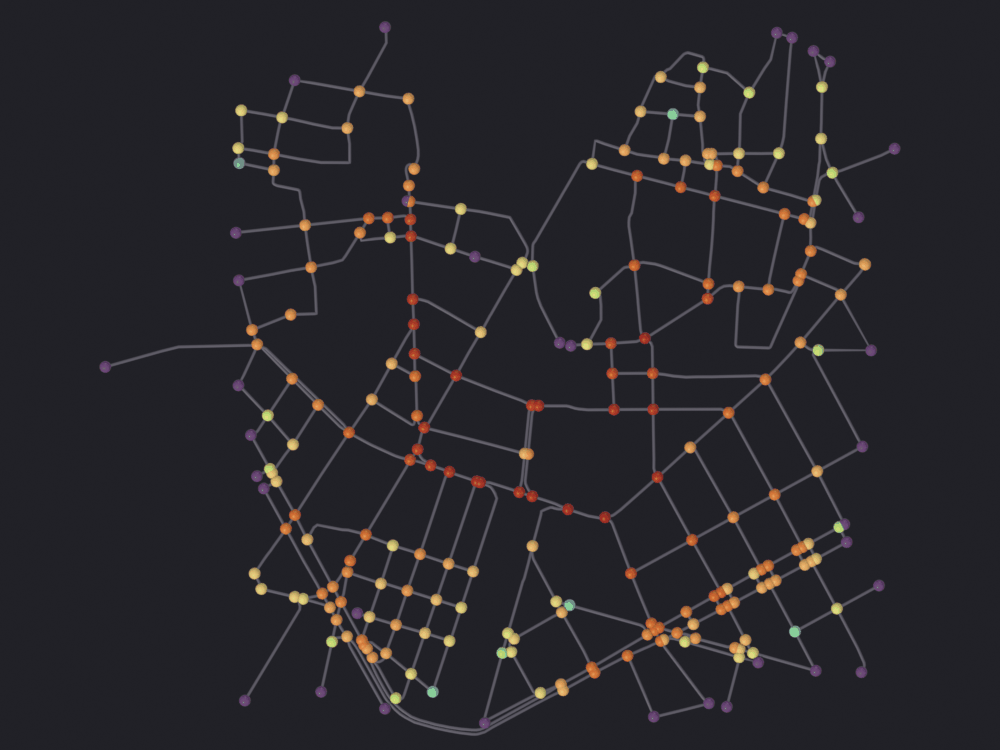
[PASS] 1_betweenness_raw.png legible — 9.3% ink (healthy range 0.5–60%)Trueclipped = nb.render(
net, "renders/10_centrality/2_betweenness_clipped",
look='ink', color_attribute="node_betweenness", clip_high_pct=98,
verbose=False)
nb.show(clipped)
nb.check_render(clipped)
print(f"ink without the clip {nb.ink(raw):.3%}")
print(f"ink with it {nb.ink(clipped):.3%}")
def plates_differ(first, second, threshold=8):
"""Fraction of pixels whose color differs between two renders.
`nb.ink()` counts pixels that are not background and cannot see a
recoloring; this can.
"""
from PIL import Image
a = np.asarray(Image.open(str(first)).convert("RGB"), dtype=np.int16)
b = np.asarray(Image.open(str(second)).convert("RGB"), dtype=np.int16)
return float((np.abs(a - b).max(axis=2) > threshold).mean())
print(f"pixels the clip moved: {plates_differ(raw, clipped):.2%}") Skipping Split Edges: 'is_intersection' present, keeping streets continuous
Info: Geometry Nodes modifier added
Info: Attribute -> node_betweenness · node_betweenness -> turbo [log] [0 … 0.2266] on Point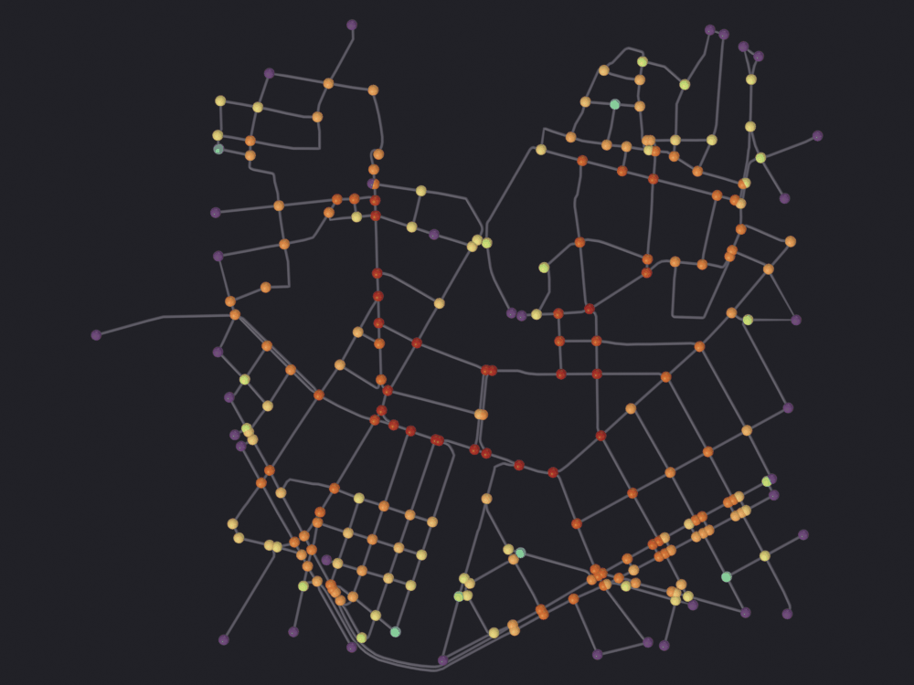
[PASS] 2_betweenness_clipped.png legible — 9.3% ink (healthy range 0.5–60%)
ink without the clip 9.290%
ink with it          9.284%
pixels the clip moved: 1.10%
check_render cannot see the difference. The ink fractions agree to a thousandth, as they should: clipping moves colors without changing how many pixels carry them. Hence plates_differ, which can.
It is needed for a second reason: a graph object keeps its previous coloring. sg.render.material() will not overwrite an existing *_SciGraphsColor material (notebooks/tools/sg.render.py:736-740) and rewires the existing color layer when it does build one (:759-765), so rendering one object repeatedly under different color_attribute= values can hand you the first coloring six times. This notebook renders one network under six quantities, so every comparison below is checked rather than assumed.
On this network the clip does very little. max / p98 is about 1.1, so the top two percent of the scale was carrying almost nothing; reclaiming it moves the busiest corridor from orange to red. On a bigger network, where one motorway takes an order of magnitude more than the 98th percentile, the same argument returns most of the ramp.
What the default actually draws
The unweighted answer that section 2 measured, on the same network. The point of the figure is that it is not obviously wrong.
The two frames cannot be compared stop for stop. vmin=/vmax= are silently ineffective on this path: scigraphs.color_set_attribute calls fn.update_property_range() before reading them (SciGraphs/ui/coloring/operators.py:374) and overwrites whatever was passed, so there is no way to pin the two renders to one absolute scale. Each has its own ramp over its own range; the comparison that means anything is the rank table in section 2.
node_attribute(net, fast_length, "node_betweenness_fast")

default_plate = nb.render(
    net, "renders/10_centrality/3_betweenness_default", look='ink',
    color_attribute="node_betweenness_fast", clip_high_pct=98, verbose=False)
nb.show(default_plate)
nb.check_render(default_plate)

moved = plates_differ(clipped, default_plate)
print(f"pixels differing between the weighted plate and this one: {moved:.2%}")

check("the two plates really are two colorings",
      moved > 0.005,
      "if this were 0 the renderer would be reusing the first material, "
      "not the measures agreeing")
Skipping Split Edges: 'is_intersection' present, keeping streets continuous
Info: Geometry Nodes modifier added
Info: Attribute -> node_betweenness_fast · node_betweenness_fast -> turbo [log] [0 … 0.2171] on Point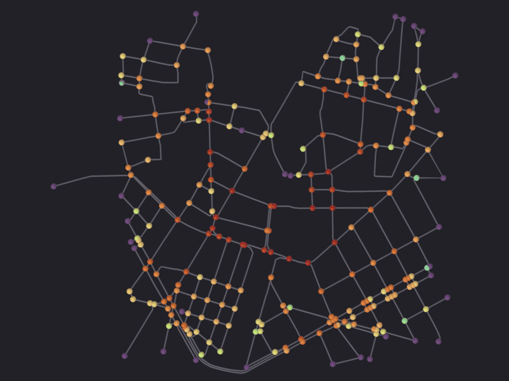
[PASS] 3_betweenness_default.png legible — 9.3% ink (healthy range 0.5–60%)
pixels differing between the weighted plate and this one: 1.59%
[PASS] the two plates really are two colorings — if this were 0 the renderer would be reusing the first material, not the measures agreeingTrue4 · Betweenness of streets, not of intersections
The part of osmnx_centrality that has no generic equivalent. edge_betweenness_line collapses the multigraph to a simple DiGraph, takes its line graph (the graph whose nodes are the original’s edges, joined when they meet) and runs node betweenness on that (core/osmnx/centrality.py:110-137). Node betweenness on the line graph is edge betweenness on the original, and the result is indexed by (u, v): one number per street segment.
The standard move in street-network analysis, and not a presentational choice. “Which junction do the through routes pass?” and “which street do they run along?” have different answers on any network with blocks, because a route entering a junction and leaving it again scores the junction once and two different streets. The second is the question a street is planned around.
t0 = time.time()
edge_bw = sg_centrality.edge_betweenness_line(G, weight="length", fast=True)
print(f"edge_betweenness_line: {len(edge_bw)} segments in {time.time() - t0:.2f} s")
print(f"  keyed by {type(next(iter(edge_bw)))}, "
      f"for example {next(iter(edge_bw))}")

values = np.array(list(edge_bw.values()))
print("\nstreet betweenness")
for p in (50, 75, 90, 95, 98, 100):
    print(f"  p{p:<3} {np.percentile(values, p):.4f}")
ranked_e = np.sort(values)[::-1]
for share in (5, 10):
    take = max(1, len(ranked_e) * share // 100)
    print(f"  top {share:>2} % of streets carry "
          f"{ranked_e[:take].sum() / ranked_e.sum():.1%} of the total")

check("there is one value per street segment",
      len(edge_bw) <= G.number_of_edges())
edge_betweenness_line: 375 segments in 0.01 s
keyed by <class 'tuple'>, for example (25767293, 25767446)
street betweenness
p50 0.0175
p75 0.0407
p90 0.0849
p95 0.1274
p98 0.1788
p100 0.2634
top 5 % of streets carry 26.0% of the total
top 10 % of streets carry 42.5% of the total
[PASS] there is one value per street segmentTrueThe operator computes it and then throws it away
Run osmnx_centrality with kind='BETWEENNESS_EDGE' and it reports success, names a range in the status bar, and writes an EDGE attribute that is entirely zero.
print("osmnx_centrality BETWEENNESS_EDGE ->",
      bpy.ops.scigraphs.osmnx_centrality(kind='BETWEENNESS_EDGE',
      weighted=True, fast=True))

written = np.array([d.value for d in net.data.attributes["edge_betweenness"].data])
print(f"  attribute domain  {net.data.attributes['edge_betweenness'].domain}")
print(f"  length            {len(written)} (mesh edges)")
print(f"  non-zero values   {int((written != 0).sum())}")
print(f"  the operator reported a range of "
      f"[{min(edge_bw.values()):.4f}, {max(edge_bw.values()):.4f}]")

# The values did reach the graph, which is where the color operators cannot
# see them.
on_graph = sum(1 for *_ids, d in G_after.edges(data=True)
               if "edge_betweenness" in d)
print(f"  segments carrying it on the NetworkX graph: {on_graph}")

check("the EDGE mesh attribute is all zeros", int((written != 0).sum()) == 0,
      "computed, stored on the graph, and then not transferred")
Info: edge_betweenness: 375 values, range [0.0000, 0.2634]
osmnx_centrality BETWEENNESS_EDGE -> {'FINISHED'}
attribute domain EDGE
length 1492 (mesh edges)
non-zero values 0
the operator reported a range of [0.0000, 0.2634]
segments carrying it on the NetworkX graph: 375
[PASS] the EDGE mesh attribute is all zeros — computed, stored on the graph, and then not transferredTrueDefect.
centrality_operators.py:120-127creates theEDGEattribute and fills it with a literal0.0in a loop, under a comment saying the edge-to-(u, v)mapping depends oncore.osmnx.mesh_bridge. That module already does the job:mesh_bridge.transfer_edge_attribute_to_mesh(obj, G, name)resolves a graph edge to the run of mesh edges that draws it, which is not one-to-one becauseretain_geometrysplits every street into several. The operator has already put the values onGtwo lines earlier (centrality_operators.py:101-104), so the fix is to call it.Nothing reports the failure.
osmnx_attr_to_colorson anEDGEattribute paints every loop(0.5, 0.5, 0.5)regardless (centrality_operators.py:203-207), the path notebook 07 §6 covers, and the status bar quotes the range of the values that never arrived.
transferred = mesh_bridge.transfer_edge_attribute_to_mesh(
    net, G_after, "edge_betweenness", mesh_attr_name="street_betweenness")
street = np.array([d.value for d in net.data.attributes["street_betweenness"].data])

print(f"transfer_edge_attribute_to_mesh -> {transferred} assignments")
print(f"  mesh edges with a value  {int((street != 0).sum())} of {len(street)}")
print(f"  range                    0 … {street.max():.4f}")
print(f"  domain                   "
      f"{sg.render.attribute_domain(net, 'street_betweenness')}")

coverage = (street != 0).sum() / len(street)
print(f"\ncoverage {coverage:.1%}: the shortfall is "
      f"`build_edge_mapping`'s breadth-first search failing to find a path "
      f"through the shape points for some segments; those mesh edges keep 0.0 "
      f"and sit at the bottom of the ramp")

check("the transfer reaches most of the mesh", coverage > 0.8,
      f"{int((street != 0).sum())} of {len(street)} mesh edges")
transfer_edge_attribute_to_mesh -> 1565 assignments
mesh edges with a value 1315 of 1492
range 0 … 0.2634
domain EDGE
coverage 88.1%: the shortfall is `build_edge_mapping`'s breadth-first search failing to find a path through the shape points for some segments; those mesh edges keep 0.0 and sit at the bottom of the ramp
[PASS] the transfer reaches most of the mesh — 1315 of 1492 mesh edgesTrueThe figure, and what it is really showing
There is no per-edge color on a graph. A color attribute lives on POINT or on CORNER, a graph mesh has no faces, so an EDGE attribute is averaged over the edges meeting at each vertex before it reaches the shader (SciGraphs/core/mesh/attributes.py:227). What follows is a vertex-averaged field. Notebook 07 quantifies the cost on an OSMnx import: three quarters of the vertices are shape points interior to a single street and take that street’s exact value, so the averaging happens only at junctions. Read the tubes, not the joints.
street_plate = nb.render(
    net, "renders/10_centrality/4_street_betweenness", look='ink',
    color_attribute="street_betweenness", clip_high_pct=98, verbose=False)
nb.show(street_plate)
nb.check_render(street_plate)

print(f"pixels differing from the junction plate: "
      f"{plates_differ(clipped, street_plate):.2%}")

check("the tubes are carrying the color now, not just the spheres",
      plates_differ(clipped, street_plate) > 0.02,
      "an EDGE attribute is promoted to POINT for the shader, which is "
      "what puts a value on every vertex along a street")
Promoted 2 edge attribute(s) to point domain for GN propagation
Skipping Split Edges: 'is_intersection' present, keeping streets continuous
Info: Geometry Nodes modifier added
Info: Attribute -> street_betweenness · street_betweenness -> turbo [log] [0 … 0.1854] on Point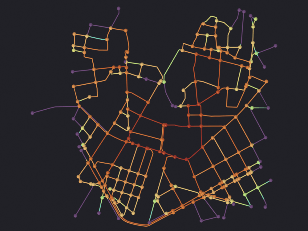
[PASS] 4_street_betweenness.png legible — 9.8% ink (healthy range 0.5–60%)
pixels differing from the junction plate: 8.66%
[PASS] the tubes are carrying the color now, not just the spheres — an EDGE attribute is promoted to POINT for the shader, which is what puts a value on every vertex along a streetTrueFigure 2 and this one do not name the same winner. Node betweenness lights the junctions along the corridor most routes have to enter; street betweenness lights the run of carriageway they then follow. If the question is where to put a crossing, it is the junction figure; if it is which street cannot be closed, this one.
Notebook 08 builds a third answer by routing a few hundred origin-destination pairs and counting how many routes use each edge. That count is a Monte-Carlo approximation of this quantity on a sample of pairs, useful when the exact computation is too slow. It is not rebuilt here.
print(f"busiest intersection  betweenness {WEIGHTED.max():.4f}")
busiest_edge = max(edge_bw, key=edge_bw.get)
data = G.get_edge_data(*busiest_edge)
name = next((d.get("name") for d in data.values() if d.get("name")), "unnamed")
print(f"busiest street        {name}  betweenness {edge_bw[busiest_edge]:.4f}")
busiest intersection betweenness 0.2573
busiest street Carrer de Xàtiva betweenness 0.26345 · Closeness, where the same defect is unmissable
Closeness is the reciprocal of the mean distance to everywhere else, so on a compact study area it is a smooth gradient peaking near the centroid rather than a set of corridors. That also makes it the measure most sensitive to where you cut the study area, and the one to distrust on a truncated graph.
It shares section 2’s defect: node_closeness hands the weights to rx.closeness_centrality (centrality.py:163), which does not take them. Here the two answers are not even in the same units. Weighted, the distances are meters and closeness comes out around 1/1000; unweighted they are hops and it comes out around 1/12. Two numbers eighty times apart, from one checkbox, both labeled closeness.
close_fast = sg_centrality.node_closeness(G, weight="length", fast=True)
close_slow = sg_centrality.node_closeness(G, weight="length", fast=False)
CF = np.array([close_fast[n] for n in order])
CS = np.array([close_slow[n] for n in order])

print(f"closeness, fast vs slow: identical = {np.allclose(CF, CS)}")
print(f"  fast=True  (hops)   range 0 … {CF.max():.5f}, mean {CF.mean():.5f}")
print(f"  fast=False (meters) range 0 … {CS.max():.5f}, mean {CS.mean():.5f}")
print(f"  ratio of the two means           {CF.mean() / CS.mean():.0f}x")
print(f"  Spearman between them            {spearmanr(CF, CS).statistic:.4f}")

check("closeness has the same weight defect",
      not np.allclose(CF, CS))
check("and the two are not even on the same scale",
      CF.mean() > 10 * CS.mean(),
      "reciprocal meters against reciprocal hops")
closeness, fast vs slow: identical = False
fast=True (hops) range 0 … 0.08640, mean 0.05593
fast=False (meters) range 0 … 0.00101, mean 0.00067
ratio of the two means 84x
Spearman between them 0.8693
[PASS] closeness has the same weight defect
[PASS] and the two are not even on the same scale — reciprocal meters against reciprocal hopsTrueThe figure takes the metric one, and it needs the opposite clip from the betweenness figures. Closeness has no long upper tail (it is bounded above by the most central node) but it has a long lower one, and on a directed graph the bottom of that tail is exactly zero: a node that nothing can reach has no finite distance to average, and the far end of a one-way stub is such a node. Those sit at the ramp’s first stop and take everything between there and the bulk with them.
zero_nodes = [n for n in order if close_slow[n] == 0.0]
print(f"intersections with closeness exactly 0: {len(zero_nodes)}")
print(f"  their in-degree: "
      f"{[G.in_degree(n) for n in zero_nodes]}, nothing reaches them")
print(f"  the rest run {min(v for v in CS if v > 0):.2e} … {CS.max():.2e}")

filled_c, mesh_closeness = node_attribute(net, close_slow, "node_closeness")

unclipped = nb.render(
    net, "renders/10_centrality/5_closeness_raw", look='ink',
    color_attribute="node_closeness", verbose=False)
nb.show(unclipped)
nb.check_render(unclipped)
intersections with closeness exactly 0: 15
their in-degree: [0, 0, 0, 0, 0, 0, 0, 0, 0, 0, 0, 0, 0, 0, 0], nothing reaches them
the rest run 3.76e-05 … 1.01e-03
Promoted 2 edge attribute(s) to point domain for GN propagation
Skipping Split Edges: 'is_intersection' present, keeping streets continuous
Info: Geometry Nodes modifier added
Info: Attribute -> node_closeness · node_closeness -> turbo [log] [0 … 0.001009] on Point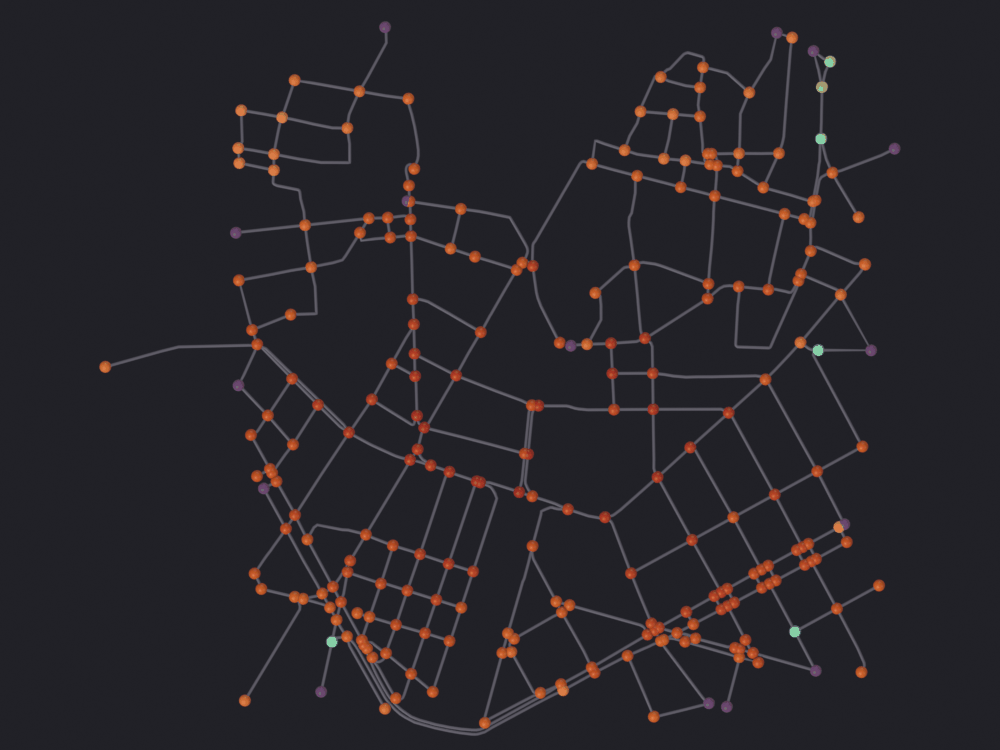
[PASS] 5_closeness_raw.png legible — 9.2% ink (healthy range 0.5–60%)TrueThe clip is computed over the mesh attribute, not the 243 node values: every vertex is a sample, and three quarters of them are street shape carrying the mean of the two intersections at either end. So the percentile that decides the ramp has to be read off the same array the renderer reads.
low = np.percentile(mesh_closeness, 2)
print(f"mesh attribute: {len(mesh_closeness)} values, "
      f"{int((mesh_closeness == 0).sum())} of them exactly 0")
print(f"  2nd percentile {low:.3e}, median {np.median(mesh_closeness):.3e}, "
      f"max {mesh_closeness.max():.3e}")
print(f"  clipping there returns "
      f"{100 * low / mesh_closeness.max():.0f} % of the ramp to the rest")

close_plate = nb.render(
    net, "renders/10_centrality/6_closeness", look='ink',
    color_attribute="node_closeness", clip_low_pct=2, verbose=False)
nb.show(close_plate)
nb.check_render(close_plate)

print(f"ink unclipped {nb.ink(unclipped):.3%}, clipped "
      f"{nb.ink(close_plate):.3%}")
print(f"pixels the low clip moved: {plates_differ(unclipped, close_plate):.2%}")

check("clipping the bottom repaints a large part of the map",
      plates_differ(unclipped, close_plate) > 0.01,
      "and the ink number, as always, is unchanged")
mesh attribute: 1374 values, 15 of them exactly 0
2nd percentile 1.015e-04, median 7.164e-04, max 1.009e-03
clipping there returns 10 % of the ramp to the rest
Promoted 2 edge attribute(s) to point domain for GN propagation
Skipping Split Edges: 'is_intersection' present, keeping streets continuous
Info: Geometry Nodes modifier added
Info: Attribute -> node_closeness · node_closeness -> turbo [log] [0.0001015 … 0.001009] on Point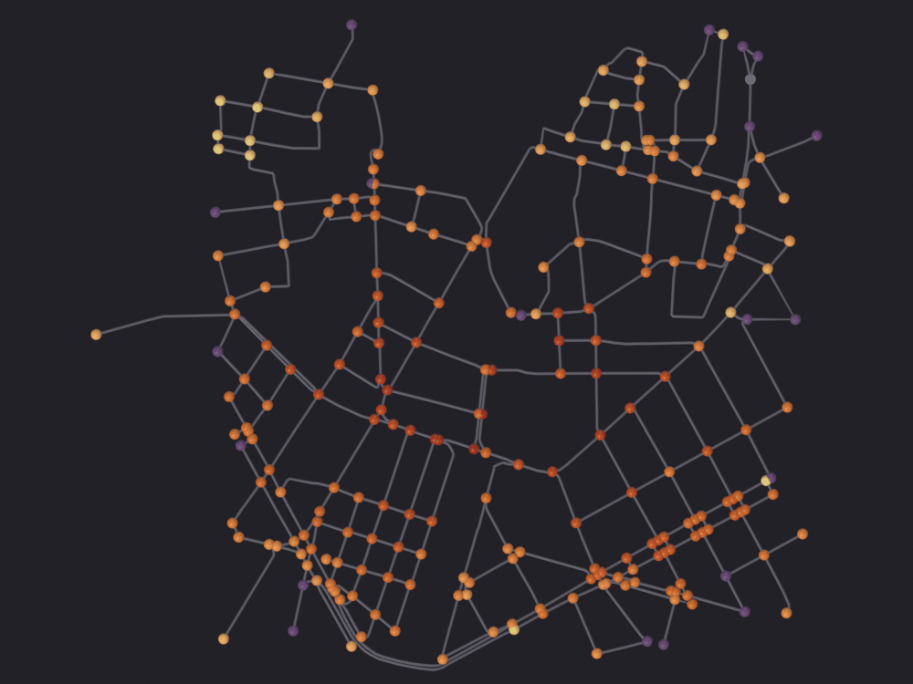
[PASS] 6_closeness.png legible — 9.3% ink (healthy range 0.5–60%)
ink unclipped 9.227%, clipped 9.308%
pixels the low clip moved: 3.44%
[PASS] clipping the bottom repaints a large part of the map — and the ink number, as always, is unchangedTrue6 · Export: what survives
All but one of the eight routes produce a file; the question is whether the numbers are in it, and whether they are still numbers when they come back. Notebook 06 §7 covers the topology round trip: graph_to_gdfs, osmnx_graph_to_gdfs, and why GeoJSON turns every scalar tag into a one-element list. This section is about the attributes this notebook computed, which nothing downstream has heard of.
scigraphs.export_graphreads the mesh: topology throughparse_graph_data_filtered, attributes throughcollect_mesh_attributes, which takesPOINT-domain numeric attributes and nothing else (core/mesh/mesh_utils.py:209-233). GraphML, GEXF, JSON, CSV.scigraphs.osmnx_exportreads theMultiDiGraphand hands it straight to OSMnx. GeoPackage, OSM XML, Gephi GraphML, SVG.
So an EDGE attribute cannot leave through the first, and a mesh attribute cannot leave through the second. Nothing says so.
out_dir = nb.out("14_centrality")
out_dir.mkdir(parents=True, exist_ok=True)

# Both places the quantity can live.
for node_id, value in reference_weighted.items():
    G_after.nodes[node_id]["betweenness_w"] = float(value)
node_attribute(net, reference_weighted, "betweenness_w")

survives = {}

point_attrs = [n for n, d, _ in sg.graphs.attributes(net) if d == 'POINT']
edge_attrs = [n for n, d, _ in sg.graphs.attributes(net)
              if d == 'EDGE' and not n.startswith(".")]
graph_node_keys = set()
for _n, d in G_after.nodes(data=True):
    graph_node_keys |= set(d)

print("what is on the object before anything is written")
print(f"  mesh POINT attributes  {point_attrs}")
print(f"  mesh EDGE attributes   {edge_attrs}")
print(f"  graph node attributes  {sorted(graph_node_keys)}")

color_layers = [n for n in point_attrs if n.endswith("_color")]
print(f"\n{len(color_layers)} of those POINT attributes are color layers "
      f"the renderer left behind:")
print(f"  {color_layers}")

check("drawing a figure adds a POINT attribute per attribute drawn",
      len(color_layers) >= 4,
      "one `<name>_color` layer per `color_attribute=` this notebook used")
what is on the object before anything is written
mesh POINT attributes ['is_intersection', 'position', 'betweenness', 'centrality_betweenness', 'node_betweenness', 'node_betweenness_color', 'node_betweenness_fast', 'node_betweenness_fast_color', 'street_betweenness_color', 'node_closeness', 'node_closeness_color', 'betweenness_w']
mesh EDGE attributes ['edge_betweenness', 'street_betweenness']
graph node attributes ['betweenness', 'betweenness_w', 'highway', 'street_count', 'x', 'y']
4 of those POINT attributes are color layers the renderer left behind:
['node_betweenness_color', 'node_betweenness_fast_color', 'street_betweenness_color', 'node_closeness_color']
[PASS] drawing a figure adds a POINT attribute per attribute drawn — one `<name>_color` layer per `color_attribute=` this notebook usedTrueWorth knowing before the tables below.
collect_mesh_attributestakes every numericPOINTattribute, andFLOAT_COLORcounts: it averages each RGBA to a scalar and exports it like any other measurement (core/mesh/mesh_utils.py:222-228). A graph that has been drawn therefore exports its own color ramp alongside its data, one extra node attribute per figure, namednode_betweenness_colorbesidenode_betweenness. Nothing marks which is which. Name the attribute you want and drop the rest on the way in.
scigraphs.export_graph, four formats
props.export_include_attributes = True
written_files = {}

for fmt, ext in (('GRAPHML', '.graphml'), ('GEXF', '.gexf'),
                 ('JSON', '.json'), ('CSV', '.csv')):
    path = out_dir / f"export_graph{ext}"
    props.export_format = fmt
    props.export_filepath = str(path)
    try:
        result = bpy.ops.scigraphs.export_graph()
    except RuntimeError as exc:
        print(f"  {fmt:<8} failed: {exc}")
        continue
    written_files[fmt] = path
    status = "ok" if 'FINISHED' in result else "canceled"
    print(f"  {fmt:<8} {status:<10} {path.name:<22} "
          f"{path.stat().st_size / 1e3:>7.1f} kB")
Info: Graph exported to notebooks/out/14_centrality/export_graph.graphml
GRAPHML ok export_graph.graphml 194.9 kB
Info: Graph exported to notebooks/out/14_centrality/export_graph.gexf
GEXF ok export_graph.gexf 246.2 kB
Info: Graph exported to notebooks/out/14_centrality/export_graph.json
JSON ok export_graph.json 173.6 kB
Info: Graph exported to notebooks/out/14_centrality/export_graph.csv
CSV ok export_graph.csv 7.2 kBback = nx.read_graphml(str(written_files['GRAPHML']))
node_keys = set()
for _n, d in back.nodes(data=True):
node_keys |= set(d)
edge_keys = set()
for _u, _v, d in back.edges(data=True):
edge_keys |= set(d)
print(f"GraphML {back.number_of_nodes()} nodes, {back.number_of_edges()} edges, "
f"directed={back.is_directed()}")
print(f" node attributes {sorted(node_keys)}")
print(f" edge attributes {sorted(edge_keys) or '(none)'}")
worst = max(abs(float(back.nodes[nid]["betweenness_w"]) - reference_weighted[int(nid)])
for nid in back.nodes if "betweenness_w" in back.nodes[nid])
print(f" largest error in betweenness_w: {worst:.3e}")
survives['export_graph GraphML'] = dict(
nodes=back.number_of_nodes(), edges=back.number_of_edges(),
directed=back.is_directed(), node_attr="betweenness_w" in node_keys,
edge_attr=bool(edge_keys), error=worst)
check("GraphML carries the computed node attribute",
"betweenness_w" in node_keys)
check("and loses the direction of every one-way",
not back.is_directed() and G.is_directed(),
"the source graph is a MultiDiGraph")GraphML 243 nodes, 375 edges, directed=False
node attributes ['betweenness', 'betweenness_w', 'centrality_betweenness', 'is_intersection', 'node_betweenness', 'node_betweenness_color', 'node_betweenness_fast', 'node_betweenness_fast_color', 'node_closeness', 'node_closeness_color', 'street_betweenness_color']
edge attributes (none)
largest error in betweenness_w: 1.447e-08
[PASS] GraphML carries the computed node attribute
[PASS] and loses the direction of every one-way — the source graph is a MultiDiGraphTrueDefect.
export_to_graphmlwritesedgedefault="directed"only whenhasattr(graph_data, 'is_directed')(core/data_io/export_utils.py:25), andGraphDatahas no such attribute: it is three fields wide (core/algorithms/graph.py:3). The condition is false for every graph the add-on can produce, so every GraphML and GEXF export comes out undirected.export_to_jsonhas the same expression atexport_utils.py:148and writes"directed": falsebeside it. Meanwhilecreate_osmnx_graph_meshstores the answer on the object asobj["is_directed"](core/mesh/geometry.py:1755) and nothing on the export path reads it.Every one-way in Ciutat Vella comes back as a two-way, and any betweenness recomputed downstream from the exported file is a different quantity from the one exported with it.
The values lose precision too: the mesh stores a FLOAT attribute in single precision, so anything routed through it comes back with about seven significant digits. Irrelevant for a centrality, fatal for a coordinate, which is why nothing in this suite moves geometry that way.
gexf = nx.read_gexf(str(written_files['GEXF']))
gexf_keys = set()
for _n, d in gexf.nodes(data=True):
    gexf_keys |= set(d)
print(f"GEXF     {gexf.number_of_nodes()} nodes, {gexf.number_of_edges()} edges, "
      f"directed={gexf.is_directed()}")
print(f"         node attributes {sorted(gexf_keys)}")
survives['export_graph GEXF'] = dict(
    nodes=gexf.number_of_nodes(), edges=gexf.number_of_edges(),
    directed=gexf.is_directed(), node_attr="betweenness_w" in gexf_keys,
    edge_attr=False, error=None)

payload = json.loads(written_files['JSON'].read_text(encoding="utf-8"))
first = payload["nodes"][0]
print(f"\nJSON     {len(payload['nodes'])} nodes, {len(payload['edges'])} edges, "
      f"directed={payload['directed']}")
print(f"         first node {json.dumps(first)[:110]} …")
print(f"         edges carry {sorted(payload['edges'][0])}")
survives['export_graph JSON'] = dict(
    nodes=len(payload["nodes"]), edges=len(payload["edges"]),
    directed=payload["directed"],
    node_attr="betweenness_w" in first.get("attributes", {}),
    edge_attr=False, error=None)

lines = written_files['CSV'].read_text(encoding="utf-8").splitlines()
print(f"\nCSV      {len(lines) - 1} rows, header {lines[0]!r}, "
      f"first row {lines[1]!r}")
survives['export_graph CSV'] = dict(
    nodes=None, edges=len(lines) - 1, directed=None,
    node_attr=False, edge_attr=False, error=None)

check("CSV is an edge list and nothing else",
      lines[0] == "source,target",
      "`export_to_csv_edges` writes two columns and ignores "
      "`export_include_attributes` entirely (export_utils.py:181-205)")
GEXF 243 nodes, 375 edges, directed=False
node attributes ['betweenness', 'betweenness_w', 'centrality_betweenness', 'is_intersection', 'label', 'node_betweenness', 'node_betweenness_color', 'node_betweenness_fast', 'node_betweenness_fast_color', 'node_closeness', 'node_closeness_color', 'street_betweenness_color']
JSON 243 nodes, 375 edges, directed=False
first node {"id": "25767293", "attributes": {"is_intersection": 1.0, "betweenness": 0.25429973006248474, "centrality_betw …
edges carry ['source', 'target']
CSV 375 rows, header 'source,target', first row '25767293,25767446'
[PASS] CSV is an edge list and nothing else — `export_to_csv_edges` writes two columns and ignores `export_include_attributes` entirely (export_utils.py:181-205)Truescigraphs.osmnx_export, four formats
A better result, because it does not go through the mesh at all: whatever is on the MultiDiGraph is what OSMnx serializes, and OSMnx has been carrying arbitrary node and edge attributes for years.
osmnx_files = {}
for fmt, ext in (('GEOPACKAGE', '.gpkg'), ('OSM_XML', '.osm'),
                 ('GRAPHML_GEPHI', '.graphml'), ('SVG', '.svg')):
    path = out_dir / f"osmnx_{fmt.lower()}{ext}"
    props.osmnx_export_format = fmt
    try:
        result = bpy.ops.scigraphs.osmnx_export(filepath=str(path))
    except RuntimeError as exc:
        message = str(exc).strip().splitlines()[-1]
        print(f"  {fmt:<14} FAILED: {message}")
        survives[f'osmnx_export {fmt}'] = dict(
            nodes=None, edges=None, directed=None,
            node_attr=False, edge_attr=False, error="refused")
        continue
    osmnx_files[fmt] = path
    print(f"  {fmt:<14} {'ok':<10} {path.name:<28} "
          f"{path.stat().st_size / 1e3:>7.1f} kB")
Info: Saved GeoPackage: osmnx_geopackage.gpkg
GEOPACKAGE ok osmnx_geopackage.gpkg 266.2 kB
Error: OSM XML export failed: Graph must be unsimplified to save as OSM XML.
OSM_XML FAILED: Error: OSM XML export failed: Graph must be unsimplified to save as OSM XML.
Info: Saved Gephi GraphML: osmnx_graphml_gephi.graphml
GRAPHML_GEPHI ok osmnx_graphml_gephi.graphml 269.1 kB
Info: Saved SVG: osmnx_svg.svg
SVG ok osmnx_svg.svg 87.3 kBOSM_XML refuses a simplified graph, and that is OSMnx being correct rather than the operator being broken: OSM XML describes ways as sequences of nodes, and a simplified graph has thrown away the nodes interior to a way. Use it to feed the download back to a routing engine, and only from osmnx_simplify-untouched data. Notebook 06 §4 keeps such a graph around.
gephi = nx.read_graphml(str(osmnx_files['GRAPHML_GEPHI']))
g_nodes, g_edges = set(), set()
for _n, d in gephi.nodes(data=True):
    g_nodes |= set(d)
for _u, _v, d in gephi.edges(data=True):
    g_edges |= set(d)
sample = gephi.nodes[next(iter(gephi.nodes))]

print(f"Gephi GraphML  {gephi.number_of_nodes()} nodes, "
      f"{gephi.number_of_edges()} edges, directed={gephi.is_directed()}")
print(f"  node attributes {sorted(g_nodes)}")
print(f"  edge attributes {sorted(g_edges)}")
print(f"  and their types {[type(v).__name__ for v in sample.values()]}")
survives['osmnx_export Gephi GraphML'] = dict(
    nodes=gephi.number_of_nodes(), edges=gephi.number_of_edges(),
    directed=gephi.is_directed(), node_attr="betweenness_w" in g_nodes,
    edge_attr=bool(g_edges), error=None)

check("the Gephi export carries every node and edge attribute",
      "betweenness_w" in g_nodes and "length" in g_edges)
check("and every value in it is a string",
      all(isinstance(v, str) for v in sample.values()),
      "GraphML with `gephi=True` writes no types; the reader has to "
      "be told what each column is")
Gephi GraphML 243 nodes, 375 edges, directed=True
node attributes ['betweenness', 'betweenness_w', 'highway', 'street_count', 'x', 'y']
edge attributes ['access', 'edge_betweenness', 'geometry', 'highway', 'id', 'junction', 'lanes', 'length', 'maxspeed', 'name', 'oneway', 'osmid', 'reversed', 'tunnel', 'width']
and their types ['str', 'str', 'str', 'str', 'str']
[PASS] the Gephi export carries every node and edge attribute
[PASS] and every value in it is a string — GraphML with `gephi=True` writes no types; the reader has to be told what each column isTrueimport geopandas as gpd
import pandas as pd
gpkg = osmnx_files['GEOPACKAGE']
gpkg_nodes = gpd.read_file(str(gpkg), layer="nodes")
gpkg_edges = gpd.read_file(str(gpkg), layer="edges")
print(f"GeoPackage layers nodes({len(gpkg_nodes)}) and edges({len(gpkg_edges)})")
print(f" node columns {list(gpkg_nodes.columns)}")
print(f" edge columns {list(gpkg_edges.columns)}")
if "betweenness_w" in gpkg_nodes.columns:
stored = gpkg_nodes.set_index("osmid")["betweenness_w"]
wanted = pd.Series(reference_weighted).reindex(stored.index)
error = float((stored - wanted).abs().max())
print(f" betweenness_w survives, largest error {error:.3e}, "
f"dtype {stored.dtype}")
print(f"\n the graph has {G.number_of_edges()} directed segments; the file "
f"has {len(gpkg_edges)} rows")
print(f" and carries {sorted(set(gpkg_edges.columns) & {'oneway', 'from', 'to', 'reversed'})}")
survives['osmnx_export GeoPackage'] = dict(
nodes=len(gpkg_nodes), edges=len(gpkg_edges),
directed=len(gpkg_edges) == G.number_of_edges(),
node_attr="betweenness_w" in gpkg_nodes.columns,
edge_attr="length" in gpkg_edges.columns, error=None)
check("the GeoPackage keeps the computed attribute as a real float",
"betweenness_w" in gpkg_nodes.columns
and gpkg_nodes["betweenness_w"].dtype.kind == "f")
check("but it is written undirected",
len(gpkg_edges) < G.number_of_edges(),
f"{G.number_of_edges() - len(gpkg_edges)} reciprocal pairs "
"collapsed into single rows")GeoPackage layers nodes(243) and edges(363)
node columns ['osmid', 'y', 'x', 'street_count', 'betweenness', 'betweenness_w', 'highway', 'geometry']
edge columns ['u', 'v', 'key', 'osmid', 'highway', 'lanes', 'maxspeed', 'name', 'oneway', 'reversed', 'length', 'edge_betweenness', 'from', 'to', 'width', 'junction', 'tunnel', 'access', 'geometry']
betweenness_w survives, largest error 0.000e+00, dtype float64
the graph has 375 directed segments; the file has 363 rows
and carries ['from', 'oneway', 'reversed', 'to']
[PASS] the GeoPackage keeps the computed attribute as a real float
[PASS] but it is written undirected — 12 reciprocal pairs collapsed into single rowsTrueDefect, and the qualification on this section’s recommendation.
ox.io.save_graph_geopackagetakesdirected: bool = False, and at that default it writesgraph_to_gdfs(to_undirected(G)): one row per undirected edge. The add-on’s wrapper calls it with the filepath and nothing else (ui/operators/osmnx/export_operators.py:26), so there is no way to ask for the directed file, and the panel offers no switch.OSMnx is explicit that this is a lossless choice: it keeps
oneway,fromandtoas edge columns, so the direction is reconstructible. It is still not what a reader will assume from a layer callededgeswith one row per street, and any edge attribute that differed between the two directions of a two-way pair, an edge betweenness among them, has had one of its two values dropped to make the row.
The SVG belongs with the figures rather than this table: _save_graph_svg projects the graph and calls ox.plot_graph with node_size=0 and black edges (ui/operators/osmnx/export_operators.py:90-93), so nothing you computed can reach it. A vector outline for a figure caption, not an export.
The round trip that matters: GraphML out and back
osmnx_save_graphml / osmnx_load_graphml is the pair for persisting a graph, and notebook 06 §7 shows it keeps the topology and the graph-level metadata the GeoDataFrame route drops. What it does to a computed attribute is the trap.
rt = out_dir / "roundtrip.graphml"
sg.graphs.activate(net)
print("osmnx_save_graphml ->", bpy.ops.scigraphs.osmnx_save_graphml(filepath=str(rt)))
print("osmnx_load_graphml ->", bpy.ops.scigraphs.osmnx_load_graphml(filepath=str(rt)))

reloaded = bpy.context.active_object
reloaded.name = "Streets_from_graphml"
G_back = graph_cache.get_osmnx_graph(reloaded)
example = G_back.nodes[next(iter(G_back.nodes))]

print(f"\n{G_back.number_of_nodes()} nodes, {G_back.number_of_edges()} edges")
print(f"graph-level metadata {sorted(G_back.graph)}")
print(f"  simplified flag    {G_back.graph.get('simplified')!r}")
print("node attributes and the types they came back as:")
for key, value in example.items():
    print(f"  {key:<16} {type(value).__name__:<8} {value!r}")

survives['osmnx_save/load_graphml'] = dict(
    nodes=G_back.number_of_nodes(), edges=G_back.number_of_edges(),
    directed=G_back.is_directed(),
    node_attr="betweenness_w" in example, edge_attr=True, error=None)

check("the attribute is still there after the round trip",
      "betweenness_w" in example)
check("and so is the `simplified` flag the GeoDataFrame route drops",
      bool(G_back.graph.get("simplified")),
      "notebook 06 §7 measures the other route, which loses it")
check("but it is no longer a number",
      isinstance(example["betweenness_w"], str),
      "`x`, `y` and `street_count` come back typed; anything you "
      "computed comes back as text")
Graph saved to notebooks/out/14_centrality/roundtrip.graphml
Info: Graph saved to notebooks/out/14_centrality/roundtrip.graphml
osmnx_save_graphml -> {'FINISHED'}
Graph loaded from notebooks/out/14_centrality/roundtrip.graphml
Creating OSMnx graph: 243 nodes, 375 edges...
Created 243 intersection vertices
Created 361 street edges in 0.01s
Total OSMnx graph creation time: 0.01s
Info: Loaded graph from roundtrip.graphml: 243 nodes, 375 edges
osmnx_load_graphml -> {'FINISHED'}
243 nodes, 375 edges
graph-level metadata ['created_date', 'created_with', 'crs', 'simplified']
simplified flag True
node attributes and the types they came back as:
y float 39.4671301
x float -0.3750385
street_count int 3
betweenness str '0.254299739878295'
betweenness_w str '0.2572614107883818'
[PASS] the attribute is still there after the round trip
[PASS] and so is the `simplified` flag the GeoDataFrame route drops — notebook 06 §7 measures the other route, which loses it
[PASS] but it is no longer a number — `x`, `y` and `street_count` come back typed; anything you computed comes back as textTrueDefect.
ox.load_graphmlcasts only the attributes on its own default list (x,y,osmid,street_count,elevationand a few more) and takesnode_dtypes=/edge_dtypes=for everything else.SciGraphs/core/osmnx/io.py:44calls it asox.load_graphml(filepath), with no way for a caller to pass the mapping, andSCIGRAPHS_OT_LoadGraphMLexposes nothing either. Through the operator there is no route by which a computed attribute comes back as a number.It fails quietly.
"0.257"is truthy, sorts and compares;sum()over the column raises, butmax()returns the lexicographically largest string, which on values in[0, 1]is whichever one starts with the highest digit. A color ramp built from it is nonsense that looks like data.
The fix is one keyword argument, called directly.
typed = ox.load_graphml(str(rt), node_dtypes={"betweenness_w": float})
example_typed = typed.nodes[next(iter(typed.nodes))]
print(f"with node_dtypes={{'betweenness_w': float}}: "
      f"{type(example_typed['betweenness_w']).__name__}")

exact = all(abs(typed.nodes[n]["betweenness_w"] - reference_weighted[n]) < 1e-12
            for n in reference_weighted)
print(f"every value identical to the original: {exact}")

check("the numbers were never lost, only the types", exact,
      "GraphML stored them at full precision; the reader had to be told")
with node_dtypes={'betweenness_w': float}: float
every value identical to the original: True
[PASS] the numbers were never lost, only the types — GraphML stored them at full precision; the reader had to be toldTrueThe table
def fmt(value):
    if value is None:
        return "-"
    if isinstance(value, bool):
        return "yes" if value else "no"
    return str(value)


print(f"{'route':<30} {'nodes':>6} {'edges':>6} {'dir':>5} "
      f"{'node attr':>10} {'edge attr':>10}")
print("-" * 72)
for route, row in survives.items():
    print(f"{route:<30} {fmt(row['nodes']):>6} {fmt(row['edges']):>6} "
          f"{fmt(row['directed']):>5} {fmt(row['node_attr']):>10} "
          f"{fmt(row['edge_attr']):>10}")
route nodes edges dir node attr edge attr
------------------------------------------------------------------------
export_graph GraphML 243 375 no yes no
export_graph GEXF 243 375 no yes no
export_graph JSON 243 375 no yes no
export_graph CSV - 375 - no no
osmnx_export OSM_XML - - - no no
osmnx_export Gephi GraphML 243 375 yes yes yes
osmnx_export GeoPackage 243 363 no yes yes
osmnx_save/load_graphml 243 375 yes yes yesIf the numbers matter, leave through osmnx_export as a GeoPackage. It is the only route that keeps the edge attributes and the node attributes as typed floats in one file QGIS opens. Its cost is the row above: the operator cannot ask for the directed file, so a two-way street is one row and any per-direction quantity has lost a value. If direction is the point, osmnx_save_graphml is the route: the only one in the table that keeps all 375 directed segments, the graph metadata and the values, at the price of a node_dtypes= argument on the way back in.
Gephi GraphML keeps everything and types nothing, right for Gephi and wrong for pandas. export_graph’s four are for topology with a scalar on the nodes, and its CSV for topology alone.
Whatever the route, no EDGE attribute leaves this add-on. Of the eight routes only the two that read the graph, GeoPackage and Gephi GraphML, carry an edge attribute at all, and only if it was put on the graph rather than the mesh.
7 · The stray .graphml
A file named .graphml, the extension with no stem, turned up in this repository’s root, written by an earlier session: 700 kB of a valid street network under a name no glob will match and no .gitignore anticipates.
SCIGRAPHS_OT_ExportGraph refuses an empty path (export_operators.py:22), so it was not that one. SCIGRAPHS_OT_SaveGraphML has no such guard: bpy.path.abspath("") returns "" unchanged (it only resolves the // prefix) and io_operators.py:47-48 appends the extension to it. The result is a bare .graphml in the process working directory, which for a Blender launched from a project folder is that folder. It goes unnoticed because the operator reports FINISHED and names the file it wrote.
The cell below reproduces it inside a temporary directory and puts the cwd back.
before = pathlib.Path.cwd()
scratch = pathlib.Path(tempfile.mkdtemp(prefix="scigraphs-stray-"))
sg.graphs.activate(net)
try:
    os.chdir(scratch)
    print(f"bpy.path.abspath('') -> {bpy.path.abspath('')!r}")
    result = bpy.ops.scigraphs.osmnx_save_graphml()
    print(f"osmnx_save_graphml() with no filepath -> {result}")
    produced = sorted(p.name for p in scratch.iterdir())
    print(f"files now in the working directory: {produced}")
    sizes = {p.name: p.stat().st_size for p in scratch.iterdir()}
finally:
    os.chdir(before)

print(f"\n{scratch.name} contains "
      f"{', '.join(f'{n} ({s / 1e3:.0f} kB)' for n, s in sizes.items())}")

check("an empty path writes a file called `.graphml`",
      ".graphml" in produced,
      "into whatever directory Blender was started from")
bpy.path.abspath('') -> ''
Graph saved to .graphml
Info: Graph saved to .graphml
osmnx_save_graphml() with no filepath -> {'FINISHED'}
files now in the working directory: ['.graphml']
scigraphs-stray-uea2isrz contains .graphml (268 kB)
[PASS] an empty path writes a file called `.graphml` — into whatever directory Blender was started fromTrueDefect.
SCIGRAPHS_OT_SaveGraphML.executetakesself.filepathstraight from the operator property, whose default is the empty string, and appends.graphmlwhen it does not already end in it (ui/operators/osmnx/io_operators.py:45-48). There is no emptiness check and no anchoring to a known directory, so from a script the argument is easy to omit and the file lands in the current directory under a name beginning with a dot, wherelswill not show it.
SCIGRAPHS_OT_ExportGraphhas the guard (export_operators.py:22-24);SCIGRAPHS_OT_LoadGraphMLhas anos.path.existsthat catches the same mistake by accident (io_operators.py:85). The save path has neither. Every notebook in this suite writes throughnb.out(...).
8 · Save
Section 6 has already left nine files in this folder as a side effect of measuring the export routes. What is missing is the plain form: the numbers as CSV keyed by osmid and by (u, v), which joins back to a spreadsheet or a QGIS attribute table without any of section 6’s questions arising.
rows = ["osmid,betweenness_weighted,betweenness_unweighted,closeness"]
for node_id in order:
    rows.append(f"{node_id},{reference_weighted[node_id]:.8f},"
                f"{reference_plain[node_id]:.8f},{close_slow[node_id]:.8f}")
(out_dir / "node_centrality.csv").write_text("\n".join(rows) + "\n",
                                             encoding="utf-8")

rows = ["u,v,name,length_m,street_betweenness"]
for (u, v), value in sorted(edge_bw.items(), key=lambda kv: -kv[1]):
    data = G.get_edge_data(u, v) or {}
    label = next((d.get("name") for d in data.values() if d.get("name")), "")
    if isinstance(label, list):
        label = " / ".join(str(part) for part in label)
    length = min((float(d.get("length", 0.0)) for d in data.values()),
                 default=0.0)
    rows.append(f'{u},{v},"{label}",{length:.1f},{value:.8f}')
(out_dir / "street_centrality.csv").write_text("\n".join(rows) + "\n",
                                               encoding="utf-8")

print("written to", nb.rel(out_dir))
for entry in sorted(out_dir.iterdir()):
    print(f"  {entry.name:<32} {entry.stat().st_size / 1e3:>9.1f} kB")
written to notebooks/out/14_centrality
export_graph.csv 7.2 kB
export_graph.gexf 246.2 kB
export_graph.graphml 194.9 kB
export_graph.json 173.6 kB
node_centrality.csv 10.4 kB
osmnx_geopackage.gpkg 266.2 kB
osmnx_graphml_gephi.graphml 269.1 kB
osmnx_svg.svg 87.3 kB
roundtrip.graphml 268.5 kB
street_centrality.csv 24.3 kBRendering
Six figures, EEVEE through nb.render, top-down orthographic for the reason notebook 13 gives: a map read at an angle cannot be measured off the page. Each is colored by a quantity computed in the cell above it: node_betweenness, node_betweenness_fast, street_betweenness, node_closeness. Clipping is per figure, each plate shown against its unclipped twin; measured, consecutive plates differ on between 1 % and 9 % of the frame.
No layout is applied anywhere here, deliberately: rebuild_edges zeroes every EDGE attribute on the way through (core/mesh/geometry.py:1227-1248, called from five places in layout_operators.py), so a single layout click after section 4 would erase the street betweenness without an error.
On Blender’s Vulkan backend, the default on Linux,
gpu.state.point_size_setdoes nothing for the add-on’s shaders, so the SciGraphs GPU engine drawsPOINTandDISKnodes exactly one pixel wide. That engine is not used here, but start Blender with--gpu-backend openglanyway;verify_notebooks.pydoes.
Summary
| Question | Call | Answer |
|---|---|---|
| Which junctions do routes pass? | osmnx_centrality, BETWEENNESS_NODE |
on the directed multigraph, unweighted unless fast=False |
| Which streets do they run along? | osmnx_centrality, BETWEENNESS_EDGE |
node betweenness on the line graph; the mesh attribute is not written |
| How central is a junction overall? | osmnx_centrality, CLOSENESS |
same weight defect, and sensitive to where you cut the study area |
| The same, on any Blender graph | calculate_centrality |
symmetrized, unweighted, mesh-based (notebook 03) |
| Get the numbers out into QGIS | osmnx_export, GEOPACKAGE |
node and edge attributes as typed floats, but written undirected |
| Get them out with direction intact | osmnx_save_graphml |
all 375 directed segments, the metadata and the values |
| Get them into Gephi | osmnx_export, GRAPHML_GEPHI |
everything, as strings |
| Read a saved graph back | osmnx_load_graphml |
topology and values survive; the types do not |
osmnx_centrality reads the real MultiDiGraph, offers edge betweenness by way of the line graph, and has a rustworkx fast path two orders of magnitude quicker on anything large. At the defaults both operators are unweighted, and only one of them admits it.
Defects pinned down here, all in the installed add-on, none of them raising anything a user would see:
Use Length Weightdoes nothing whileUse Rustworkx (Fast)is on (core/osmnx/centrality.py:53,:78,:163);- turning the weight off raises
TypeError: keywords must be stringsfrom**{None: value}atcentrality.py:38, swallowed at:56, fatal at:118; BETWEENNESS_EDGEwrites anEDGEattribute of literal zeros (centrality_operators.py:120-127) and reports the range it did not transfer;mesh_bridge.transfer_edge_attribute_to_meshis what it needed;- neither centrality operator calls
mesh_utils.expand_node_values_to_mesh(centrality_operators.py:115-119); - every GraphML, GEXF and JSON export is undirected, because
hasattr(graph_data, 'is_directed')is always false (core/data_io/export_utils.py:25,:80,:148); export_to_csv_edgesignoresexport_include_attributes(export_utils.py:181-205);- the GeoPackage export takes OSMnx’s
directed=Falseand the wrapper offers no way to change it (export_operators.py:26); collect_mesh_attributesexports the renderer’sFLOAT_COLORlayers as data (core/mesh/mesh_utils.py:222-228), one decoy per figure drawn;ox.load_graphmlis called with nonode_dtypes(core/osmnx/io.py:44), so a computed attribute returns as a string;osmnx_save_graphmlwith an empty path writes.graphmlinto the working directory (io_operators.py:45-48).
That closes the OSMnx suite. Next: 15 · Abstract graphs.